 Back in 2006 when stopped at a gas station on my way to the remote town of Trinidad on the southern coast of Cuba I was approached by a chap who asked for a lift. That is quite normal there, if you drive with an empty car then you would feel guilty if you had no passengers. It is quite normal and socially acceptable to be asked for a lift like that. As we drove, he told me the saga of how he had ridden out a recent Hurricane. Basically that involved finding a good bottle of something quite strong and then huddling down to ride it out. Living through such an violent storm in a costal town is quite an intense experience, so the need for something to dull the senses is wholly understandable.
Traditionally the words “Hurricane” and “Typhoon” describe exactly the same thing, we just use the term “Typhoon” to describe Tropical Cyclones within a Pacific context and the word “Hurricane” to describe them within an Atlantic context, but hey, why am I telling you something you already know.
Actually, that is not strictly correct, because such storms in the northeast of the Pacific are also referred to as Hurricanes.
You might also perhaps guess this next bit, but as the storms rotate, the direction depends upon where on the planet the storm is. They will rotate counter-clockwise in the northern hemisphere and clockwise in the southern hemisphere (Hint: yes, it is very much down to planetary rotation). This means that the clockwise-rotating storms will generally occur off the Australian coast, and in the Indian Ocean.
What does the term “Super Typhoon” mean?
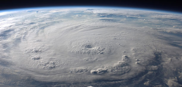
A Super Typhoon is basically a storm where the wind speeds exceed 150 miles per hour for a minimum of one minute.
In a Hurricane context that would be what is known on the Saffir–Simpson hurricane wind scale (SSHWS) as a Category 5. This, not quite the same, but it is close enough because on that scale Category 5 involves a wind speed of 157 mph or greater.
Either way, we are not simply talking about your roof being blown off, but instead the complete structural failure of entire buildings.
Super Typoons do happen. So far one of the most dramatic examples was Typhoon Haiyan in November 2013. That brought wind speeds of 195 miles per hour with gusts as high as 235 miles per hour to the Philippines. There they will on average have as many as six or seven typhoons each year. However, Haiyan was unique, because nothing of such an intensity had ever been previously recorded.
You might also be wondering about Katrina back in 2005. Yes, that was also a Category 5; it saw sustained wind speeds of up to 175 mph.
What Part does Climate Change play in all this?
There is a new paper in Nature that has examined the impact of climate change. It is entitled …
Global warming-induced upper-ocean freshening and the intensification of super typhoons
Basically the hypothesis is this.
- More global heat leads to more rain. If you raise the temperature then you quite obviously get more evaporation taking place over the oceans.
- That evaporated water does not simply vanish, but instead results in more rain. That rain in turn will then change the near-surface salinity of the ocean.
- When that happens in places where typhoons form, is that it tends to reduce the ability of Typhoons to cool the upper ocean, and that in turn leads to more intense Typhoons.
Well yes, the extra heat does of course also play a role. What is new about this paper is that it specifically examines the role that the extra freshwater has on it all.
Beyond the Abstract
They introduce the topic quite nicely. As a contrast to many papers, the opening is quite readable …
The northwestern tropical Pacific Ocean is home to nearly a third of all tropical cyclones, making it the most active basin globally1. Tropical cyclones in the northwestern Pacific, commonly referred to as typhoons, are also some of the largest2 and most destructive storms in the world, with impacts on many East Asian countries and Oceania islands. Super typhoons (STYs), equivalent in strength to an intense Category 4 or Category 5 hurricane, are particularly devastating. For instance, STY Haiyan made landfall in the Philippines in November 2013 as one of the most intense tropical cyclones in recorded history. The associated storm surge inflicted catastrophic damages, including nearly 6,000 fatalities and economic damages exceeding $800 million3. With many coastal areas in this region experiencing some of the highest rates of sea-level rise worldwide4, better knowledge of future changes in typhoon intensities is pertinent.
… and then they move directly into explaining the mechanism in play …
As typhoons intensify by extracting energy from the warm ocean surface, the underlying sea surface temperatures (SSTs) are critical for their development5. The strong winds of typhoons induce vigorous mixing of the upper ocean, a process that tends to reduce SST through entrainment of colder water from below the surface mixed layer6. The resultant cooling of SST subsequently acts as a negative feedback on the typhoon’s intensity through its impact on air–sea enthalpy fluxes7,8,9,10,11,12,13. Thus, the state of the upper ocean, including near-surface stratification, plays an important role in the intensification of typhoons. Near-surface ocean stratification is particularly important for the development of intense tropical cyclones, which are characterized by deep mixing of the upper ocean and strong sea surface cooling14,15. Hence, changes in upper-ocean stratification under global warming may critically affect future STYs.
In other words, the extra water from the additional rain plays a role, and as it increases it will impact what happens …
On average, the northwestern tropical Pacific receives some of the highest rainfall in the global tropics and hence is characterized by low-salinity surface waters. Furthermore, mounting evidence suggests that rainfall in the western tropical Pacific is increasing relative to evaporation20,21 and the surface is freshening22,23, leading to a strengthening of the upper-ocean salinity stratification.
OK, let’s step back and take a second pass at this to help make things a bit clearer.
The energy engine that drives a tropical cyclone is basically the evaporation of moisture from the warm ocean surface. This is why they weaken when they hit land, their primary source of energy is gone. So there are basically three steps to understanding this …
- The violent intensity of such storms will cause a deep mixing of the upper ocean with the lower colder deeper ocean, and that cools things down and makes it less intense. This is essentially a negative feedback loop.
- If however you dump lots more freshwater into the mix (rainfall), then that disrupts this deep mixing and cooling.
- Net effect is that the storms become more intense.
Clearly many different factors are in play.
So what happens when you use a data model to crunch the numbers?
The entire point of the paper is that they plugged these observations into climate model simulations to see what would happen. This is what they found …
we show that freshening of the upper ocean, caused by greater rainfall in places where typhoons form, tends to intensify STYs [Super Typhoons] by reducing their ability to cool the upper ocean. We further demonstrate that the strengthening effect of this freshening over the period 1961–2008 is ∼53% stronger than the suppressive effect of temperature, whereas under twenty-first century projections, the positive effect of salinity is about half of the negative effect of ocean temperature changes.
Translation: Global Warming is going to make the Super Typhoons more intense.
I believe the technical term that has the potential to perhaps sum that up just might be “yikes”.