 Geologists from the University of Sydney have discovered that a 26km land mass called Sandy Island that can be seen on charts and maps – including Google Maps – does not in fact exist. An island was thought to exist between Australia and the French territory of New Caledonia, but there is no satellite image of it. This almost feels like a page right out of “lost“, and at 26km, it is indeed large enough to qualify as the “lost” island.
A few scientists on a sea trip to investigate plate tectonics were curious about it, so decided to stop by and investigate. The Guardian tells the story …
The Australian scientists, led by Maria Seaton, a geologist at Sydney University, had embarked on a voyage to study plate tectonics. They spotted that the enigmatic island lay along their route.
But there were several puzzling discrepancies: though the island appeared on the Google Earth map, there were no images of it.
It had also featured for the past 12 years on the usually reliable world coastline database. But there was no sign of it on their sea chart.
Dr Steven Micklethwaite, a crew member from the University of WesternAustralia, recalled: “We went upstairs to the bridge and found that the navigation charts the ship uses didn’t have it.
“And so at that point we thought: Well, who do we trust? Do we trust Google Earth or do we trust the navigation charts? ”
The scientist added: “This was one of those intriguing questions. It wasn’t far outside of our path. We decided to actually sail through the island … Lo and behold there was nothing! The ocean floor didn’t ever get shallower than 1300 metres below the wave-base. There’s an island in the middle of nowhere that doesn’t actually exist.”
Micklethwaite told the Sydney Morning Herald that the ship’s captain was nervous about running aground and proceeded cautiously as they made their “un-discovery”.
Heretics, how dare they contradict the holy scientific charts, clearly the charts are right and reality is wrong … oh wait, this is science, we allow new data to adjust the things that are wrong, so we can quite happily burn the old charts, print new ones and update the on-line versions.
Anyway, here is a clip of Geologist Sabin Zahirovic explaining that it is possible that human error during the process of digitizing maps created Sandy Island.
There are a couple of other possibilities here, so lets explore a few.
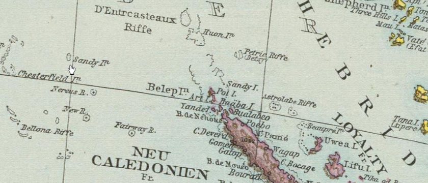
It is just a mistake Google made? Actually no, the island appears on some quite old maps. Below is a German map from 1881, and yes, there it is.
One other very common suggestion is that it is a copyright trap. Some map makers are known to include false entries so that they can then catch attempts to copy their intellectual property. It really does happen, a spokesman for the Geographer’s A–Z Street Atlas company claimed there are “about 100” trap streets included in the London edition of the street atlas, and it really does work, in a 2001 case in the UK, the Automobile Association in the United Kingdom agreed to settle a case for £20,000,000 when it was caught copying Ordnance Survey maps. So is this an example of such a copyright trap? No, while modern map makers do indeed create traps, doing so in older navigational charts would be a potential disaster, so was not a deliberate act.
So what really Happened?
The first recorded reference to it dates from 1792 when Antoine Bruni d’Entrecasteaux first mentioned some small islands at the edge of New Caledonia:
“On the 30th we discovered to the eastward a few islets, which seem to terminate this archipelago. Their height gradually diminished in proportion to their distance from New Caledonia; they seem to be a continuation of the mountains of that large island, the bases of which, covered by the sea, rise here and there to form so many islets. The gradual diminution of the height of these mountains must induce a presumption that there are hereabouts, even to a great distance, shoals, which increase the danger of navigating these seas, a conjecture not without foundation.’ The islands which D’Entrecasteaux saw here he named Moulin, Reconnaissance, Lebert, and Sandy. Of course his cursory examination will only suffice to warn the navigator from approaching them.”
– A Directory for the Navigation of the Pacific Ocean, vol. 2, London 1851, p. 829
And that was it? Actually no, that describes it as one of the Chesterfield islands to the west. So why is it now marked further east? Apparently what happened next is that the whaler ‘Velocity’ supposedly spotted it in 1876 and recorded it at 19°14’S 159°56’E but should have actually noted it to be at 19°50’S 158°51’E (If curious, try those refs in Google maps and you will see what I mean).
Données hydrographiques douteuses / International Hydrographic Bureau, Pt. E: South Pacific Ocean; Monaco 1968 – 1969 (3rd ed.) (p. 48))
This apparent re-sighting was taken by contemporary cartographers as a corroboration of the previous D’Entrecasteaux’s discovery of 1792, hence our lost Sandy Island, which is really one of the Chesterfield islands to the west. Clearly some plonker on the whaler made a rather basic longitudinal error of the Easternmost islets of the Chesterfield Group to the West and wrote down a ‘9’ instead of an ‘8’ … but sadly his mistake was picked up as truth and rippled on out from map to map over the years all the way into Google maps.
In many ways, it is all rather sad, I’ve been reliably informed that the lost Sandy islanders had a thriving red herring industry.

Laughj if you like, but before I heard of this island, and my reason for looking it up, comes from a strange psychic experience when I was told the name of the island (Taka..something…forgotten now) and I was told it meant “The island that never was” Take this as it comes. I was told the island was inhabited only by women. That is as far as the experience went.